When Erin Roared: The Atlantic’s Fiery Visitor Sends Ripples Along the Eastern Seaboard
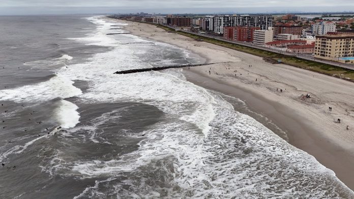
On a restless late summer day, as the Atlantic whispered and then roared, Hurricane Erin carved a path of palpable tension along the U.S. East Coast. From the shifting sands of North Carolina’s Outer Banks to the rugged shores of Virginia and even the distant outposts of Bermuda, coastal communities found themselves grappling with the raw force of a storm whose reach extended far beyond its swirling center.
Outer Banks: Where the Road Meets the Sea
There’s a haunting photo circulating on social media—waves, tall and unyielding, crashing over the loneliest artery linking the Outer Banks islands to the mainland. Locals refer to this thread-like road simply as “the causeway,” but during Hurricane Erin’s fury, it became a battleground between nature’s might and human perseverance. For Sarah Greene, a lifelong resident of Hatteras Island, this was more than just flooding—it was a reminder of the precariousness of island life.
“It’s like the ocean reminded us, ‘I’m still the boss here,’” Greene told me over the crackling line of a shaky phone connection. “We’ve seen storms before, but there’s something different about Erin—it’s not just the wind, it’s the water coming up and saying, ‘You can’t come in or out today.’”
Indeed, the surging waves rendered portions of the main highway near impassable, stranding drivers and raising fresh concerns about evacuation capabilities should the storm have taken a more ominous turn. The Outer Banks, with their storied history of shipwrecks and salty resilience, once again found themselves at the mercy of the Atlantic’s caprices.
A Slow March North: Erin’s Lingering Threat
While the Mid-Atlantic bore the brunt, the National Hurricane Center’s warnings echoed along the coastline. Erin, a Category 2 storm at this point, carried winds clocked at a formidable 169 km/h (about 105 mph), hunched in a slow crawl north-northeastwardly with a deliberate menace. But it wasn’t just the gusts that commanded respect. It was the vast, tumbling seas—notoriously deceptive—that brought the gravest danger.
“Rip currents spawned by Erin are like invisible hands in the water,” explained Dr. Lila Martinez, a coastal oceanographer specializing in storm surges at the University of North Carolina. “Even miles away from where the eye is, these currents can pull an unsuspecting swimmer far out to sea very quickly. The National Hurricane Center’s advisory against entering the water isn’t paranoid alarmism—it’s lifesaving.”
States from North Carolina to New England were urged not just to prepare for heavy weather but to heed the unseen risks lurking beneath the storm-fed waves. Rescue teams, lifeguards, and local governments stepped up patrols and public alerts, striving to prevent tragedies compounded by human misjudgment.
Bermuda: Islands in a Storm’s Shadow
Farther out in the ocean, Bermuda—known for its alabaster beaches and vibrant coral reefs—felt Erin’s distant breath. Tourists who had come for serene stretches of sand and calm waters found themselves confined to indoor spaces, watching as the island’s shaken palm trees bowed to gusts and brine-laced winds.
Local hotel owner Andre Thompson recounted the mood on the island:
“We tell guests, ‘Look, you came for paradise, but sometimes paradise is a little wild.’ The rough seas aren’t just an inconvenience—they’re a reminder of the ocean’s power, especially this time of year.”
With rough seas predicted to last until the following day, beaches were closed, and fishermen stayed ashore, echoing a tradition as old as these islands themselves: respecting nature’s ebb and flow.
The Bigger Picture: Erin in the Era of Climate Change
Erin’s tropical fury is not occurring in a vacuum. This hurricane season, officially spanning from June 1 to November 30, has already given meteorologists much to ponder. With five named storms so far—notably modest compared to some years—Erin’s emergence and its brief flirtation with Category 5 status last weekend stand out sharply.
To put that into perspective: the last Category 5 storm recorded in the Atlantic was Hurricane Milton in October 2024. Erin joined an elite—but ever-growing—set of vortices that have captured attention not just for their ferocity but for the growing intensity and unpredictability linked to a warming planet.
“Warmer ocean waters act like fuel for storms—they feed moisture and energy into what would otherwise be more ordinary hurricanes,” says Dr. Priya Khanna, a climate scientist at the NOAA. “We’re seeing not only stronger winds but also heavier rainfall and higher storm surges. These are signatures of a climate system under stress.”
Higher sea levels—rising by an average of 3.3 millimeters annually globally—means that even smaller storm surges can flood areas previously considered safe. The enhanced rainfall associated with warmer atmospheres turns once manageable storms into potential disasters. The implications span beyond weather reports—this is about communities, economies, and the very landscapes people call home.
What Does This Mean for Us?
Reading about Erin’s tempestuous journey across the Atlantic invites us all to reflect on a few pressing questions: How do we prepare for storms that are growing in strength even as their paths become less predictable? What sacrifices are we willing to make to protect vulnerable coastal communities? And how do we reconcile our historical connection to these shores with the looming realities of climate change?
In the Outer Banks, the answer still seems to be simple yet poignant—resilience and respect. As local fisherman Mike Jenkins put it:
“We don’t control the ocean, and storms remind us of that every time. But we learn. We adapt. We rebuild. That’s our way of life here.”
As the winds of Erin subside and the waves retreat, an uneasy calm returns—but the echoes of the storm persist. In this increasingly volatile climate, every hurricane season is a story of nature’s raw power entwined tightly with human vulnerability and determination.
So the next time you feel a sudden gust or glance out to see waves pounding the shore, ask yourself: What storm stories will these waters hold tomorrow? And how will we answer the call to face them?


